When Hurricane Erin begins intensifying off the Texas coast or any tropical system threatens your community, every minute counts. Understanding how to use real-time hurricane tracker technology effectively can be the difference between adequate preparation and potentially life-threatening consequences. Modern hurricane tracking has evolved dramatically, with today’s forecasts being up to 75% more accurate than they were in 1990.
The Science Behind Hurricane Path Prediction
Hurricane tracking technology combines multiple sophisticated systems working in perfect harmony. Real-time hurricane tracker systems utilize data from satellites positioned thousands of miles above Earth, Hurricane Hunter aircraft flying directly through storm centers, and advanced computer models processing over 1.5 billion observations daily. The National Hurricane Center’s Hurricane Analysis and Forecast System (HAFS), operational since 2024, represents the pinnacle of this technology, providing forecasts extending up to seven days with unprecedented accuracy.
The most critical component involves understanding atmospheric steering patterns. Hurricanes don’t move randomly – they’re guided by wind currents detected over locations as far away as the Rocky Mountains and Great Plains. When meteorologists analyze wind patterns over Colorado or Wyoming today, they’re gathering clues about where a hurricane will track along the Gulf or Atlantic coasts in the coming days.
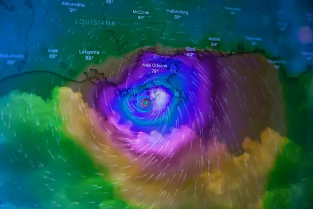
Reading the Cone of Uncertainty Like a Pro
The iconic “cone of uncertainty” remains one of the most misunderstood aspects of hurricane tracker technology. For 2025, the National Hurricane Center has reduced cone sizes by 3-5% in the Atlantic basin and up to 10% in the Eastern Pacific due to improved forecast accuracy. However, this cone only captures the storm center’s probable path about 60-70% of the time.
Understanding cone dimensions proves crucial for family safety planning. At the 24-hour mark, the cone extends approximately 45 miles wide, expanding to 245 miles at the five-day forecast point. The cone represents circles of historical forecast errors over the past five years, with each circle encompassing two-thirds of previous prediction mistakes at that time interval.
Critical misconception alert: The cone doesn’t show where hurricane impacts will occur. Storm surge, flooding, and dangerous winds often extend well beyond the cone boundaries, sometimes affecting areas hundreds of miles from the projected center track.
Essential Technology Tools for Family Protection
Professional-Grade Applications
RadarOmega stands out as the premier choice for serious storm tracking, offering high-resolution radar data, tropical weather outlooks, and customizable map layers. The application provides desktop access across multiple platforms and includes lightning detection capabilities. For comprehensive hurricane monitoring, this represents the gold standard among tracking applications.
NOAA’s Hurricane Hunter Integration brings unprecedented detail through innovative flight patterns. Since 2018, the Gulfstream-IV aircraft flies dual rings around hurricanes – an outer and inner circumnavigation pattern that has improved track forecast accuracy significantly. This enhanced data collection translates directly to better predictions available through official tracking channels.
Consumer-Friendly Options
Hurricane by American Red Cross offers family-focused features including emergency planning guidance and “I’m safe” messaging capabilities across social media platforms. Clime (formerly NOAA Weather Radar) provides offline tracking functionality, crucial when power outages affect internet connectivity.
The Weather Channel app delivers comprehensive coverage with over 100 million downloads, while Windy.com offers professional-grade visualization tools accessible to general users. These applications democratize access to sophisticated meteorological data previously available only to professionals.
Real-Time Safety Implementation Strategies
Immediate Action Timeline
36 Hours Before Impact: Review evacuation routes, fill vehicle gas tanks daily, and activate family communication plans. Ensure all household members understand evacuation zones using official county mapping tools. Download offline maps and weather applications before internet connectivity becomes unreliable.
24 Hours Before Impact: Finalize shelter decisions based on the latest hurricane tracker updates. If evacuation becomes necessary, leave immediately when your zone receives official orders – don’t wait until the last minute. Emergency management officials use sophisticated storm surge modeling combined with real-time hurricane tracker data to make these determinations.
12 Hours Before Impact: Secure outdoor objects, board windows, and ensure all emergency supplies remain accessible. Monitor real-time hurricane tracker updates every few hours, as storms can change intensity rapidly, particularly during overnight hours when warm ocean waters transfer maximum energy.
Family Communication Protocols
Establish redundant communication methods recognizing that traditional phone lines often become overloaded during emergencies. Text messaging typically proves more reliable than voice calls during disasters. Designate an out-of-state contact person, as long-distance connections frequently remain operational when local networks fail.
Create primary and secondary meeting locations – one within your immediate community and another outside your area. This dual-location strategy accounts for scenarios where neighborhood-specific impacts prevent access to your primary gathering point.
Advanced Warning System Integration
Modern hurricane tracker technology extends far beyond simple path prediction. The integration of artificial intelligence through partnerships between NOAA and Google DeepMind has revolutionized forecasting capabilities. These AI models process atmospheric data at unprecedented speeds, providing forecasters with insights that traditional physics-based models might miss.
Emergency Alert Systems provide multiple notification channels through FEMA applications, local government alerts, and National Weather Service warnings. Configure these systems for multiple geographic locations, especially if family members work or attend school in different areas than your primary residence.
Storm Surge and Inland Flooding Awareness
Hurricane impacts extend hundreds of miles inland, making real-time hurricane tracker monitoring essential even for non-coastal residents. Storm surge historically represents the leading cause of hurricane-related fatalities in the United States, yet many people focus exclusively on wind speed categories.
The HURREVAC platform combines National Hurricane Center forecast data with sophisticated inundation modeling to help emergency officials determine evacuation timing and scope. Understanding your specific flood risk zone proves crucial, as hurricane-related flooding can occur in areas never previously affected by tropical systems.
Technology Limitations and Backup Planning
Despite remarkable advances in hurricane tracker accuracy, meteorologists acknowledge that forecast precision may be approaching theoretical limits due to atmospheric chaos theory. Current 48-hour forecasts match the accuracy of 24-hour forecasts from two decades ago, but further improvements face fundamental physics constraints.
Satellite data challenges pose emerging concerns for hurricane tracking capabilities. Recent losses in microwave observation satellite coverage could impact forecasters’ ability to detect rapid intensification, particularly during overnight hours when visual monitoring becomes impossible. These “sunrise surprises” – storms that strengthen dramatically overnight – represent one of forecasting’s greatest challenges.
The Bottom Line for Family Safety
Real-time hurricane tracker technology provides unprecedented capability for protecting families, but only when used correctly and combined with solid emergency planning. The most sophisticated forecasting system becomes useless without proper preparation, clear evacuation plans, and understanding of local risk factors.
Remember that hurricane impacts often begin well before the storm’s center approaches your location. Tropical storm-force winds can extend hundreds of miles from the hurricane’s eye, and these conditions make evacuation impossible once they arrive. Use real-time hurricane tracker information to make early decisions rather than waiting for perfect certainty that never comes.
The technology exists today to provide your family with life-saving information. The key lies in understanding how to interpret this data correctly and act decisively when the situation demands immediate response. Modern hurricane tracker systems represent one of meteorology’s greatest success stories – leverage this technology effectively, and you’ll have the tools needed to keep your family safe when nature unleashes its most powerful storms.