Hatteras Island has always captivated travelers with its pristine beaches and rich maritime history, but this summer, the spotlight has shifted to safety as Hurricane Erin’s surge approaches. With powerful winds and record-high tides threatening the Outer Banks, understanding Hatteras Island evacuation and coastal flood risks amid Hurricane Erin’s surge is critical for both residents and visitors. In this post, we’ll break down the latest news, share real-time statistics, and offer practical tips to help you stay safe and prepared.
Why Hatteras Island Is Especially Vulnerable
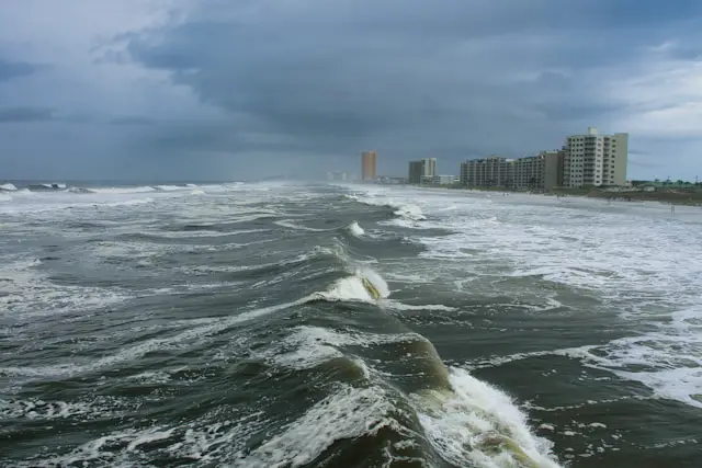
Hatteras Island is a thin barrier island that guards Pamlico Sound from the Atlantic Ocean. Its low elevation and narrow landmass make it prone to inundation when storm surges coincide with high tides. For Hurricane Erin, meteorologists predict a storm surge of up to 7–9 feet along the northeastern Outer Banks, leading to potentially devastating flooding in Hatteras Village and surrounding communities.
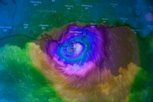
Tracking Hurricane Erin: Latest Updates
As of August 18, 2025, Hurricane Erin has intensified to a Category 3 storm with sustained winds of 125 mph. The National Hurricane Center (NHC) warns of:
- Storm Surge: 7–9 feet above ground in the most vulnerable coastal sectors
- Rainfall: 6–12 inches, with isolated totals up to 18 inches
- Wave Heights: 15–20 feet, capable of ripping apart poorly constructed piers and docks
These conditions fuel coastal flood risks amid Hurricane Erin’s surge, warranting immediate evacuation protocols. You can track real-time updates on the NHC’s official advisory page .
Understanding Evacuation Zones
North Carolina’s Division of Emergency Management has divided the Outer Banks into four evacuation zones (A–D) based on flood risk. Hatteras Island primarily falls into Zones A and B, where flooding is most severe. Local officials have ordered a mandatory evacuation for Zones A and B effective August 18 at 6:00 PM EDT.
Evacuation Zone Quick Guide
- Zone A: Low-lying areas within 500 feet of the shoreline
- Zone B: Areas within 1,000 feet of the shoreline and most vulnerable roads
- Zone C & D: Higher elevation inland regions with reduced surge risk
Residents and tourists in Zones A and B must leave immediately via NC Hwy 12 northbound. Refer to the North Carolina Emergency Management website for detailed maps and shelter locations.
Real-Life Impact: Lessons from Past Storms
In 2019, Hurricane Dorian triggered a 7-foot surge on Hatteras Island, closing Highway 12 for two weeks and stranding over 600 residents. Local businesses, including the iconic Hatteras Harbor Marina, faced over $2 million in damage. That experience underscores the importance of swift evacuation before floodwaters breach the roadway.
Preparing Your Evacuation Plan
To navigate Hatteras Island evacuation and coastal flood risks amid Hurricane Erin’s surge, follow these practical steps:
- Assemble an Emergency Kit
- Water: At least one gallon per person per day for three days
- Non-perishable food: Three-day supply
- Medications and first-aid supplies
- Flashlights, batteries, and portable chargers
- Secure Your Property
- Elevate outdoor furniture and electronics
- Install storm shutters or board up windows
- Move vehicles to higher ground
- Plan Your Route
- Use NC Hwy 12 northbound; expect heavy traffic and possible road closures
- Identify alternative routes via US-158 or US-64 if cuts to Hwy 12 occur
- Communications
- Sign up for local alerts via the FEMA app
- Keep a battery-powered radio tuned to NOAA Weather Radio
- Pet and Livestock Care
- Confirm pet-friendly shelters in advance
- Arrange transport and temporary boarding for livestock and horses
Monitoring Coastal Flood Alerts
Coastal flood advisories are issued when water levels are expected to rise beyond normal tidal conditions, often leading to minor street flooding and hazardous driving conditions. During Hurricane Erin, the National Weather Service has issued “Coastal Flood Advisory” alerts for the entire Outer Banks, with recurring warnings every high tide cycle (approximately every 6 hours). Check the latest flood forecast on the NOAA Tide Predictions page .
What Happens If You Stay?
Choosing to remain on Hatteras Island during a mandatory evacuation carries serious consequences:
- Rescue Delays: First responders prioritize life-threatening emergencies; stranded individuals may wait hours for assistance.
- Limited Supplies: Local stores typically run out of essentials within the first 24 hours of a storm advisory.
- Infrastructure Damage: Flooded roads, downed power lines, and debris pose severe hazards.
Recovery and Return: When to Come Back
Authorities advise waiting at least 24 hours after the all-clear notice before returning. This ensures roads are passable and emergency teams have completed initial damage assessments. Even then, travel with caution:
- Drive slowly through standing water—under 6 inches can cause loss of control.
- Watch for hidden debris and downed power lines.
- Report any immediate hazards to local emergency management.
Conclusion
Hurricane Erin’s surge brings Hatteras Island evacuation and coastal flood risks to the forefront. By staying informed, following evacuation orders, and preparing proactively, you can protect life and property. Remember, it only takes one bad decision to turn an adventure into a disaster. Stay safe, stay prepared, and keep an eye on trusted sources for the latest updates.